

After successfully loading ESA's 3D seismic data into a GIS and loading it into an online 3D map, the next logical step is to load your own, proprietary seismic data into ArcGIS. That next step is the SEG-Y to GIS tool, now ready to deploy from the GOM3 toolbar in ArcGIS Pro. This tool is accessible with the Geophysical Addon and now available as a standalone tool for those without the Addon, including for use outside of the Gulf.
 This interactive display of the Mahogany field is an example of combining 3D seismic data with wells, sands and other GIS data. Sand-body reservoirs are colored by the estimated ultimate recovery. Salt is shown in pink.
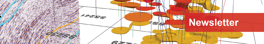
Clicking the 3D SEG-Y to GIS tool opens a window to choose the SEG-Y file. More input is needed for the conversion, such as the coordinate system and units of the seismic data, so the header of the SEG-Y file can be read if a separate document isn't available with this information.


From there, the conversion tool will open to enter the various inputs, including the output location, sample rate, data type (amplitude vs. velocity) and decimal shift. These inputs are necessary to properly set up the geographic data to integrate with other GIS data.
The processing time will vary based on the size of the SEG-Y file, though a rough guide of one minute per gigabyte is estimated in the processing status at the bottom of the window once the Run button is clicked.

From there, the new file can be added to a 3D scene in ArcGIS Pro (Local scene) as a Voxel Layer. Naturally, it is easiest to load the data into an existing Field View or Seismic 3D Scene from the GOM3 toolbar or Hotlink. Normal operations such as setting symbology are available on this layer, which is similar to the settings of a raster.
With the seismic data in the 3D scene, all of the functionality to analyze and slice through the seismic data will be at your disposal. This process combines all of the existing sand, well, paleo, production and other GIS data available with your seismic data in a truly innovative manner.
 A brief overview displaying sand-body reservoirs while slicing through 3D seismic.