


The GOM3 Geophysical Addon has been centered around our ability to allow you to bring publicly released 3D seismic data into the 3D component of ArcPro. While we continue to add publicly available 3D surveys to the Geophysical Addon, we accomplished two much larger goals.
The first is a new set of tools that will allow you to bring your modern, proprietary 3D seismic surveys into the 3D component of ArcPro. There it can be used with vector and raster data (yours and ours). We have also upgraded all of our well bores that have digital logs to legend them in the 3D scene by individual curves (e.g., resistivity, gamma, gas components, lithology, etc). The first tool to convert SEG-Y to a GIS format was completed last summer (read more here). With the newest update, another seven tools have been added to the Geophysical Addon package. Below is a quick rundown of those tools.
The second innovation is that these tools will also allow you to create a web viewer through which you can create 3D GIS web scenes – with your 3D seismic, as well as vector data (sands, wells, paleo and more). These can be easily distributed within your organizations to allow users easy access to 3D seismic with nothing more than a simple browser using your internal web services. This will provide you with giant leverage to distribute critical data 3D throughout your company to users without requiring them to know or access ArcGIS Pro.
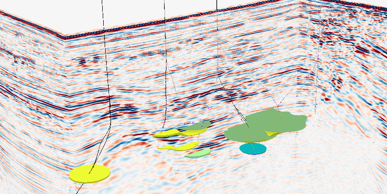 Sands and wells of the Allegheny field with 3D seismic data integrated.
The first tool, as noted before, converts SEG-Y data to a GIS-formatted multi-dimensional array, indexed for performace while handling the coordinate system and conversion to a 3D grid. This first tool is paired with another tool that converts the SEG-Y header to a text file for ease of use.
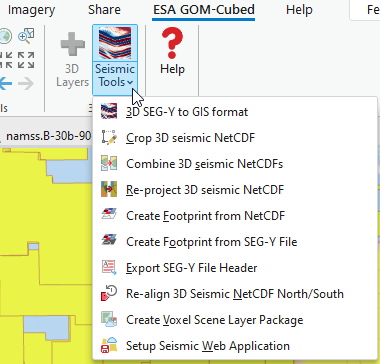
The next tools to highlight create a footprint of the area covered by a seismic survey, especially useful when none is provided with the original data. One tool works on the original SEG-Y file and the other works with the converted GIS file.
At this point, the basics of being able to use, integrate and manipulate the seismic data will be ready for ArcGIS Pro. The other tools are designed to optimize the data for use in a web browser.
Loading an entire survey into a browser, although possible, can be time-consuming if the survey is particularly large. The Crop 3D Seismic tool allows you to interactively choose a portion of the survey to crop into a new file.
Because a survey can be divided into multiple files, the conversion to a GIS format is also multiple files. However, if the important portion is along the edge of the two files, it is necessary to use the Combine 3D Seismic tool to manipulate the seismic data as one.
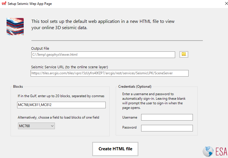
Once the area is set, it may be necessary to adjust coordinate systems because of limitations in the way that ArcGIS Online or Enterprise can handle the 3D grids. The Re-project 3D seismic tool and Re-align 3D seismic North/South tool can be used for the final preparation of the data to upload. Once the display of the data is set, the Create Voxel Scene Layer tool is used and the final packaged is uploaded. Finally, the Setup Seismic Web Application tool will customize a new web page to automatically load your data and, if in the Gulf, integrate GOM3 data as well.
This page can be sent or used within your website in whatever way works best for you. It will automatically have functionality to slide through the seismic section. This page of the Mahogany field (as shown below) is a great example of what to expect. We look forward to helping you make the leap of advancing your GIS work to include 3D seismic data.
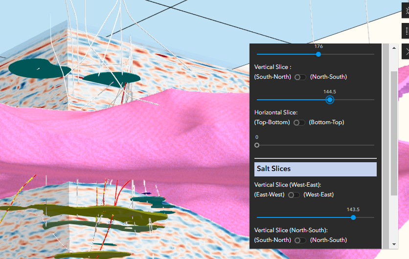 An interactive example using the Mahogany field in Ship Shoal.