GOM3 Geophysical Addon


The GOM3 Geophysical Addon provides data and functionality to view the Gulf of Mexico in a unique way. Building on top of the 3D component of GOM3, this Addon integrates 2D and 3D seismic data, well log values and salt maps with just a few clicks. There is no simpler way of viewing vector data, well logs and voxels in one interactive display.
As listed above, the Geophysical Addon currently has five major components, beginning with all of the publicly released, 2D and 3D seismic data in the northern Gulf of Mexico. This means not only all of the SEG-Y data; the seismic data has been converted into GIS-ready formats that integrate into 3D scenes with wells, sands, perforation intervals and paleo picks at the click of a button. The next component are the salt datasets, which come in two forms. First, salt is extracted from the velocity data in 3D seismic surveys, when available. The top of salt has also been extracted from pattern recognition algorithms using 2D seismic surveys. The fourth component is the display of over ten common well log curves along the boreholes in the 3D scenes, taken from an exhaustive process of choosing the best logs for each well. Last but not least, three other well datasets are included in the Geophysical Addon: geomarkers, hydrocarbon bearing zones and mud weights.

3D Seismic
Much more dramatic than a well-organized collection of data files, the Geophysical Addon successfully integrates over 400 3D surveys and over 8,000 2D lines into the 3D component of GOM3. For 3D seismic data, clicking on the survey footprint in a map launches a 3D scene with wells, sands, perforation intervals, paleo samples and all 3D seismic line sections, including salt and velocity surveys where available. The integration of these datasets enhances the geologic context in exciting new ways, all while being fast and easy as shown in this video.

In all, over 130,000 square miles of 3D seismic is already available (covering over 60,000 square miles with overlap) and new surveys will be added as they are released by BOEM/BSEE.
Coverage
2D Seismic
Compromising over 250,000 line-miles of seismic depth sections, the 2D seismic dataset collects all publicly released 2D lines in the Gulf of Mexico. These lines are loaded when viewing a single field so that the time-to-depth conversion is as accurate as possible in a localized region. Each line can be turned on or off individually or sliced in a similar way to the 3D seismic (in the video above) by using standard swipe tools in the GIS. Although any new 2D seismic data from BOEM/BSEE will be included, it appears all recent updates are of 3D seismic only at this point in time. This short video displays lines in the SS154 field from four different surveys of various years/vintages:


Well Logs
Once digital well logs were again distributed directly by the BSEE, the data were immediately integrated into GOM3, first linked as downloads from the wells, then in an online viewer to explore the logs in a viewer (see here), and now along the boreholes in 3D scenes, integrated with sands, perforations and seismic data. This process involved an evolving 'Golden Set' of curves, handling multiple logs per well to find the longest, deepest and, ultimately, best logs to display. Although the online viewer displays logs at 1-foot intervals, the 3D GIS display is in 25-foot averages, to maintain performance. They have been mapped to highlight the most important values, as seen here:

Salt
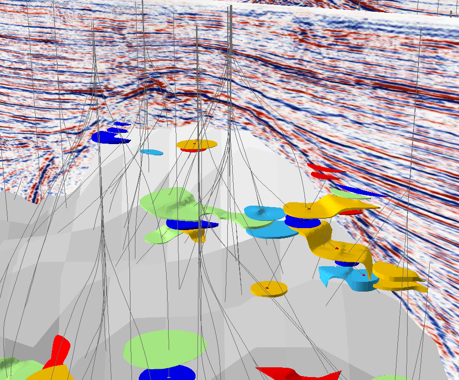
No geologic variable in the GOM has played a greater role than salt in the accumulation of oil and gas. Over half the discovered oil (over 12 billion bbls) and a third of the gas (66 TCF) were found in traps directly related to salt. In the Geophysical Addon, salt has been extracted in two very different ways. In the 3D Seismic Scenes, salt is extracted from the velocity cubes based on the sharp break in velocities that occur where salt is located. These dramatic displays are loaded automatically with the 3D Seismic Scenes as shown here:
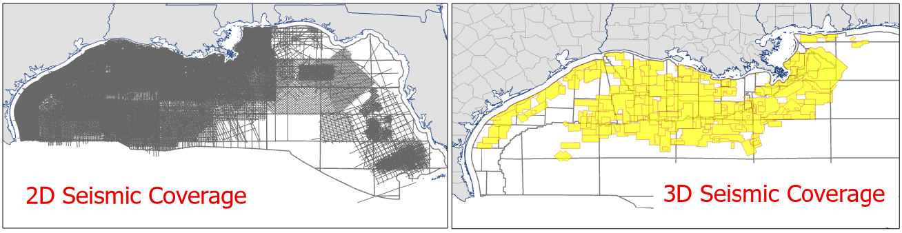
But the original work on salt involved the thousands of 2D seismic lines across the Gulf. Covering a whole basin, this is a unique collection of seismic data and invited us to analyze all of the lines collectively using machine-learning techniques. For a basin in which salt has played such a central role in forming oil and gas fields, the first priority was discriminating salt on all of the lines and producing a basin-wide top of salt map.
The last 5 years of the geophysical literature reports a few experiments in machine-identification of salt but these projects typically include only a few lines as examples and employed “supervised learning.” Supervision means the algorithms required an input set of salt/no-salt examples prepared in advance by geophysicists. By contrast, we applied our technique to 8,000 lines and employed “unsupervised learning,” meaning that our algorithms were not given a set of examples of what is and isn’t salt.
Salt1
The top of salt at Ship Shoal 154.
Using these salt boundaries within the images, the top of salt was found and mapped to create a basin-wide top of salt map for most of the western and central regions of the Gulf of Mexico. The first-generation Gulf-wide top of salt map is included in the new Geophysical Addon in three ways: as a map in time, in depth and as 3-D surfaces introduced into the 3-D field models of GOM3, providing greater context to the reservoir and well data.
SaltDepth
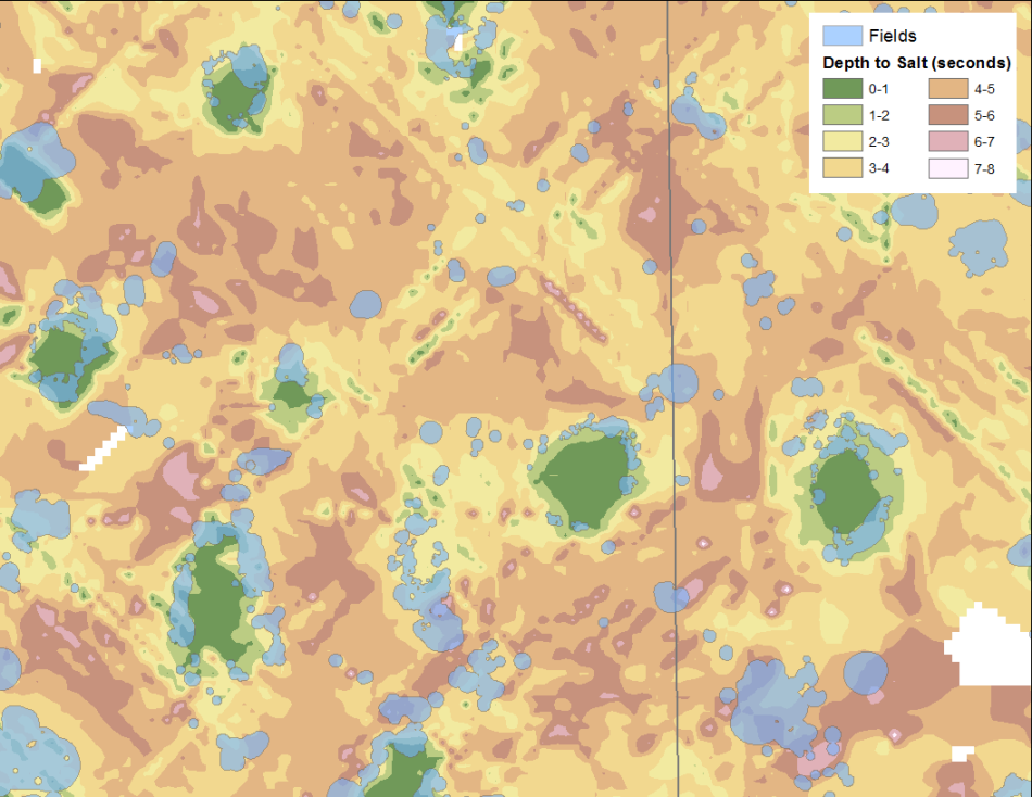
Depth to the top of salt in central Eugene Island and Ship Shoal areas.
Geomarkers, Hydrocarbon Bearing Zones & Mud Weights
Even more well data has been mapped in three dimensions for analysis in the Geophysical Addon. Geomarkers, Hydrocarbon Bearing Zones and Mud Weight values have been collected from the operators' weekly reports dating back to 2000 and are loaded into 3D scenes along their repective boreholes. These datasets are updated monthly for all subscribers to the Geophysical Addon.

HBZ
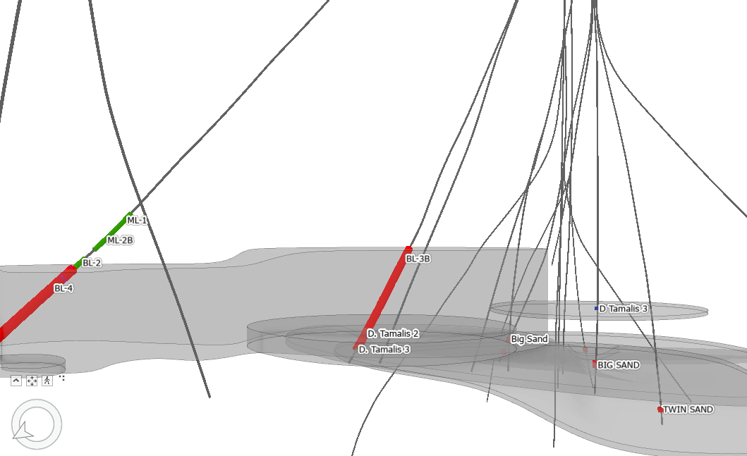
Hydrocarbon Bearing Zones, labeled and colored by type within transparent, grey sands of Garden Banks 260.

For information about subscribing to the Geophysical Addon or to schedule a demo, please contact us at contactesa@earthsci.com or call: 562-428-3181.